As ice melts in the Arctic?
2017-10-22 14:23
As ice melts in the Arctic?
If you look at smaller regions, you can get a more detailed picture of what is happening.

Sign up for news “UkrMedia” in Facebook, Twitter or Google+
Every year in the Arctic are one and the same process: cap of sea ice in the Arctic ocean and melts throughout the spring and summer retreat until you reach the annual minimum, reports Rus.Media. When the ocean and the air grow cold with the arrival of autumn, the ice cover grows again and the cycle continues. But if you look at smaller regions, you can get a more detailed picture of what is happening.
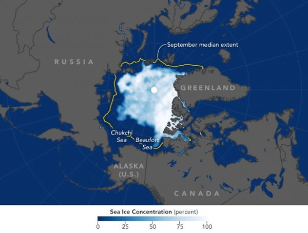
The map above shows the area covered by Arctic sea ice on September 13, when the ice reached its minimum for the year. The extent of sea ice, locations where the concentration of ice is at least 15 %. The map was made based on observations of satellite Global Change Observation Mission 1st-Water, which is led by the Japanese aerospace research Agency.
The yellow outline shows the median sea ice, which was observed in September from 1981 through 2010
According to the National data center of snow and ice, Arctic ice cover in 2017 fell to 4.64 million square km, and is the eighth in the poverty index over the 39 years of satellite observations. Making graphs of these annual minimums and maximums, the researchers found a steep decline in the total volume of Arctic sea ice in the satellite era. But the decline in different regions of the Arctic ocean varies. The Beaufort sea North of Alaska, for example, a region where sea ice is decreasing the fastest.
This year the ice in the Chukchi sea and Beaufort sea reached a minimum by the end of September, no later than the Arctic as a whole. The chart shows that the ice in the two seas are still declining, while in other regions began to freeze. The melting lasted the longest in the Beaufort sea, which finally started to freeze after the ice minimum reached on September 27.

The loss of ice in the Beaufort sea and the Chukchi sea has not been a record this year, but the scale was much lower than usual. Notice on the map the edge of the ice in these seas was distributed considerably further North than average. According to Walt Meier, a scientist from the National data center of snow and ice, Chukchi sea and Beaufort sea entered the season of melting large volumes of ice pirogovskogo. This type of ice is thinner than multi-year ice (which has survived previous seasons of melting), and melts much faster.
Meyer also notes that weather a low pressure system was kept near the North pole most of the summer. “Low pressure keeps it colder in General and leads to a relatively higher area of the ice in General, says Meyer. — However, the location of the minimum of this year led to the formation of winds that blow from the South and West. They help to move the ice from these regions. Also winds can bring warm ocean water from the Bering Strait region”.
YOU MAY ALSO LIKE
 Chinese Challenger To Nvidia Mints A New Billionaire As Its Stock Soars Over 420% In Trading Debut
Founder Zhang Jianzhong has amassed a fortune of $4.3 billion based on his stake in Moore Threads.
Zhang Jianzhong, founder of ...
READ MORE Semiconductors: the US has revealed a plan to counter China
«Cutting costs, creating jobs, strengthening supply chains and countering China». The headline of the press release published on ...
READ MORE Americans accused Tik Tok of sharing user data with China
Although TikTok has always stated that it prevents any transfer or viewing of its users' data in China, where its parent company ...
READ MORE The Suffren project: the first French nuclear submarine of the new generation enters service
France officially put into operation on Friday, June 3, in Brest (Finisterre) its first nuclear attack submarine (SNA) of a new ...
READ MORE A Guide to Adding the Best Sound Effects to Your Podcast
Do you intend to include sound effects in your podcast?
Consider your favorite film or television. Sound effects are often deployed ...
READ MORE Microsoft: «The fears of European cloud operators are justified»
Brad Smith, the president of the American giant, announced in Brussels about concessions for its software and hosting services in ...
READ MORE